

We stayed with my Aunt Shirley in Phoenix through Tuesday. On Wednesday and Thursday we would stay in Flagstaff then head back to Phoenix on Friday morning.

 On Sunday
we stayed local and explored. I drove
through my old neighborhood, by my old high school, up North Mountain,
etc. I found a spot to take night
pictures but forgot my tripod so would have to go back.
On Sunday
we stayed local and explored. I drove
through my old neighborhood, by my old high school, up North Mountain,
etc. I found a spot to take night
pictures but forgot my tripod so would have to go back.On Monday met with Steve, Amy, Seth, and Alyssa for breakfast at Denny’s. Seth joined us as we headed out to Cave Creek to explore. We saw an ATV rental place and stopped to check it out. We made plans to rent ATV’s Tuesday afternoon. Later that day I dropped Kevin off with Seth at the Pointe at Squaw Peak. They had fun at the water park.

 Tuesday,
Seth, Kevin, and I headed back to Cave Creek to ride ATV’s. Seth and Kevin have motocross bikes so were
excited to try ATV’s in the desert. We
were given a map and instructions on what trails to take. There were trail number markers at various
times and were told what trails to stay on.
Tuesday,
Seth, Kevin, and I headed back to Cave Creek to ride ATV’s. Seth and Kevin have motocross bikes so were
excited to try ATV’s in the desert. We
were given a map and instructions on what trails to take. There were trail number markers at various
times and were told what trails to stay on.I brought my hunting GPS in anticipation of a hike or ride. When I turned it on I had a blank screen with the compass arrow and no terrain maps. I forgot to download the topo maps of Arizona. Mistake by ME ... I could still use the GPS by leaving it on the whole time. It would leave a breadcrumb trail showing where we had come from and I could set waypoints, etc.. We were riding North of Cave Creek so it was all new territory. My other thought was “How am I going to keep up with these guys?” Our riding improved the longer we rode and as we got more comfortable.


 Back in the day I had
several motorcycles growing up in Phoenix.
I used to start riding my Yamaha 250 from the Circle K at 19th Avenue
and Bell Road. I rode North and West
from that location which was all open desert. One time I rode from
that starting point all the way to Cave Creek never seeing
another person or rider. Phoenix has now expanded so
there are houses and roads from that starting point almost all the way to Cave Creek. There's also a canal with Colorado River water now cutting through my old riding
area.
Back in the day I had
several motorcycles growing up in Phoenix.
I used to start riding my Yamaha 250 from the Circle K at 19th Avenue
and Bell Road. I rode North and West
from that location which was all open desert. One time I rode from
that starting point all the way to Cave Creek never seeing
another person or rider. Phoenix has now expanded so
there are houses and roads from that starting point almost all the way to Cave Creek. There's also a canal with Colorado River water now cutting through my old riding
area.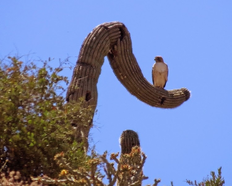
 Seth,
Kevin, and I followed the trails and ended up at the Verde River where we were
going to turn around. When we arrived
there was a Sheriff’s helicopter, 6 trucks, ATV’s and probably 20 Sheriff
Deputy’s there. Seth and Kevin headed to
the river and I asked one Sheriff if this location was a meeting point. He said “There's something going on in the
area”. Being the responsible adult with
2 teenage boys I asked if we should leave.
He said “You're ok for now.” … Hmm … needless to say I made the
decision to leave after about 10 minutes …
Seth,
Kevin, and I followed the trails and ended up at the Verde River where we were
going to turn around. When we arrived
there was a Sheriff’s helicopter, 6 trucks, ATV’s and probably 20 Sheriff
Deputy’s there. Seth and Kevin headed to
the river and I asked one Sheriff if this location was a meeting point. He said “There's something going on in the
area”. Being the responsible adult with
2 teenage boys I asked if we should leave.
He said “You're ok for now.” … Hmm … needless to say I made the
decision to leave after about 10 minutes …We went back the way we came. At one of the forks in the trail we went the wrong way and got lost. Not good. I looked at my GPS to help get us back to where we unloaded the ATV’s. We were getting close but none of the trails we were on took us in the correct direction. I remember we passed under power lines driving to where we parked and unloaded the ATV’s. When getting instructions I was told if we hit the power lines we went too far. With no trails going the direction we needed to go I headed for the power lines. Once there we took the power line trails to the road.
We rode our ATV’s on the road for about a mile and turned on to the dirt road we took to get to the parking area. We spotted the truck and trailer so all was good. With so many small trails going all directions my GPS (even without the topo maps) really helped get us back to where we started. My GPS said we rode 27 miles. Our time was almost up so we loaded up the ATV’s and headed back to town.

 That night
I went back to take some night pictures.
This is a view of 7th Street in Phoenix.
I experimented with shutter speeds up to 15 seconds. I got a bit creative by moving my camera
while the shutter was open which causes the light trails. I haven’t taken time lapse photographs for a while so
had fun experimenting again.
That night
I went back to take some night pictures.
This is a view of 7th Street in Phoenix.
I experimented with shutter speeds up to 15 seconds. I got a bit creative by moving my camera
while the shutter was open which causes the light trails. I haven’t taken time lapse photographs for a while so
had fun experimenting again.
 We were up
early on Wednesday and drove to Flagstaff.
We unloaded and headed south on 89a through Oak Creek Canyon to
Sedona. The rock formations and colors
are outstanding.
We were up
early on Wednesday and drove to Flagstaff.
We unloaded and headed south on 89a through Oak Creek Canyon to
Sedona. The rock formations and colors
are outstanding.


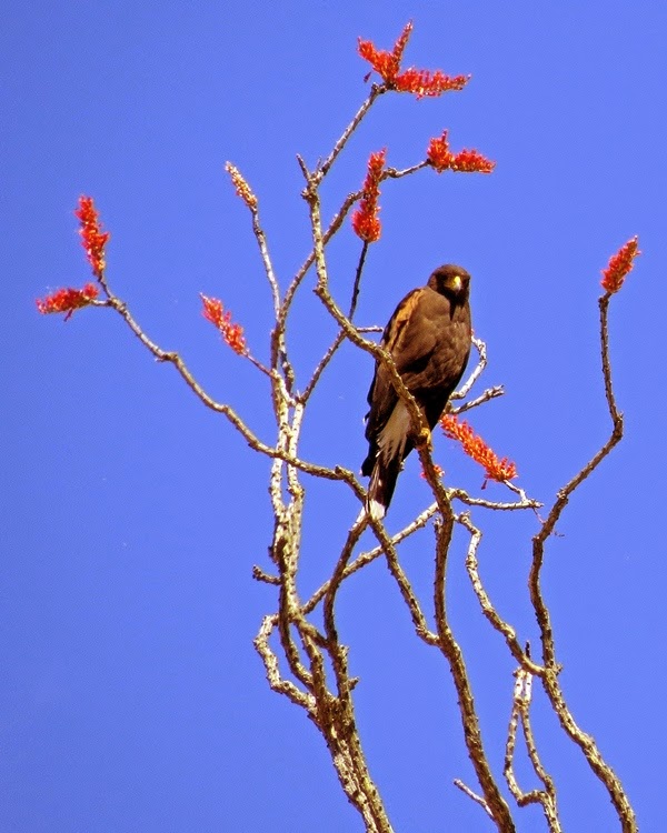
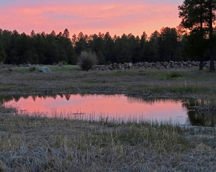 Up the road from my Aunt's place in Flagstaff there was a marsh area with trails. With elk in the area I really wanted to spot some and take pictures. Lots of tracks but no elk. I did take some bird pictures, sunrise and sunset pictures with the Snow Bowl in the background.
 Next we
headed down some back roads, on to 89a, ending up in Jerome. It is a neat old mining town with lots of
history. Because of the extensive mining
many of the old buildings are sliding down the mountain. They said the old jail is 225 feet down the
hill from where it was built. We headed
back to the Cottonwood area to visit one of my old friends. We had Mexican food in Sedona. It was very good. Kevin drove back up Oak Creek canyon. It's always fun with the corners and steep ascent
but especially in this convertible Camaro.
Next we
headed down some back roads, on to 89a, ending up in Jerome. It is a neat old mining town with lots of
history. Because of the extensive mining
many of the old buildings are sliding down the mountain. They said the old jail is 225 feet down the
hill from where it was built. We headed
back to the Cottonwood area to visit one of my old friends. We had Mexican food in Sedona. It was very good. Kevin drove back up Oak Creek canyon. It's always fun with the corners and steep ascent
but especially in this convertible Camaro.


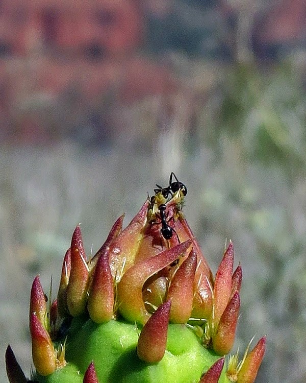 When people visit places like Sedona and the Grand Canyon it is immense with so much BIG scenery. I started thinking about the little things. Here are a couple shots I took remembering the little things. Cactus with rocks in the background ... Focus on Cactus ... Bulb on Cactus not yet blooming ... Ants on bulb ... Remember the little things too.
 Thursday morning
up early and headed to the Grand Canyon.
We went around Agassiz Peak, the second highest mountain in U.S. state
of Arizona at 12,356 feet. This is the
snowy peak you see in my photos. Snow Bowl
ski area is on that mountain.
Thursday morning
up early and headed to the Grand Canyon.
We went around Agassiz Peak, the second highest mountain in U.S. state
of Arizona at 12,356 feet. This is the
snowy peak you see in my photos. Snow Bowl
ski area is on that mountain.
 We arrived
and parked at the Grand Canyon Visitor Center.
We walked several miles along the rim of the canyon. It started out a bit hazy but clouds showed
up and seemed to take the bite out of the sun.
I took some good pictures but the camera doesn’t do the canyon
justice. I don’t think the camera can
capture the depth of field appropriately. They do have free shuttle buses in
case you get tired of walking.
We arrived
and parked at the Grand Canyon Visitor Center.
We walked several miles along the rim of the canyon. It started out a bit hazy but clouds showed
up and seemed to take the bite out of the sun.
I took some good pictures but the camera doesn’t do the canyon
justice. I don’t think the camera can
capture the depth of field appropriately. They do have free shuttle buses in
case you get tired of walking.
 Views of the Grand Canyon are breathtaking. It is hard to capture the size of what you
are really looking at with a camera. In
the Canyon there are trails, camping areas, a ranch, and buildings in various
locations for hikers or the mule teams.
My friend Shawn has hiked to the bottom many times on 3-9 day treks. You can see some of the trails from the top
but not much else unless you have binoculars, a spotting scope, or in my case a
camera with a good zoom lens.
Unfortunately I forgot my binoculars ...
Views of the Grand Canyon are breathtaking. It is hard to capture the size of what you
are really looking at with a camera. In
the Canyon there are trails, camping areas, a ranch, and buildings in various
locations for hikers or the mule teams.
My friend Shawn has hiked to the bottom many times on 3-9 day treks. You can see some of the trails from the top
but not much else unless you have binoculars, a spotting scope, or in my case a
camera with a good zoom lens.
Unfortunately I forgot my binoculars ...
 Here is an example.
Using my zoom lens I panned and was able to spot some activity below. This first picture is a normal photo looking
at the canyon with no zoom. I put a
circle around what I spotted. Do you see
anything in the circle? When I zoom in
on that same area you can now see a black rectangle. When I zoom in all the way you see the
building, hitching rails, hikers, backpacks, etc. Looks like the hikers were getting ready to
head out. If you go back to the first photo with the tiny circle you would never see it. As we continued walking I
pointed out the Phantom Ranch to Kevin. Again,
with a zoom we could see the ranch buildings and people walking on the trails,
etc.
Here is an example.
Using my zoom lens I panned and was able to spot some activity below. This first picture is a normal photo looking
at the canyon with no zoom. I put a
circle around what I spotted. Do you see
anything in the circle? When I zoom in
on that same area you can now see a black rectangle. When I zoom in all the way you see the
building, hitching rails, hikers, backpacks, etc. Looks like the hikers were getting ready to
head out. If you go back to the first photo with the tiny circle you would never see it. As we continued walking I
pointed out the Phantom Ranch to Kevin. Again,
with a zoom we could see the ranch buildings and people walking on the trails,
etc.Bring your binoculars … You’d be surprised how much more you can see from the rim.

 We left
the Grand Canyon toward Sunset Crater.
When I visited as a kid we could climb to the top and look in the
crater. Not anymore … We took the 52
mile Wupatki and Sunset Crater National Monuments Loop Road. Kevin and I enjoyed the Indian ruins. I really liked the grasslands with the Painted
Desert in the distance. This was one of Kevin's favorite parts of our trip.
We left
the Grand Canyon toward Sunset Crater.
When I visited as a kid we could climb to the top and look in the
crater. Not anymore … We took the 52
mile Wupatki and Sunset Crater National Monuments Loop Road. Kevin and I enjoyed the Indian ruins. I really liked the grasslands with the Painted
Desert in the distance. This was one of Kevin's favorite parts of our trip.
 Friday
morning I decided to visit a friend in Wickenburg which was south and somewhat
on the way back to Phoenix. Kevin drove
down Oak Creek Canyon this time. 89a
took us back up through Jerome and through more very winding roads to
Prescott. From there we took 89 to
Wickenburg. After our visit we headed to
Phoenix past Lake Pleasant. When I lived
in AZ there was no Dam so Lake Pleasant was small compared to now. We passed 2 shooting ranges (one with a 1000 yard
range). Tempting …
Friday
morning I decided to visit a friend in Wickenburg which was south and somewhat
on the way back to Phoenix. Kevin drove
down Oak Creek Canyon this time. 89a
took us back up through Jerome and through more very winding roads to
Prescott. From there we took 89 to
Wickenburg. After our visit we headed to
Phoenix past Lake Pleasant. When I lived
in AZ there was no Dam so Lake Pleasant was small compared to now. We passed 2 shooting ranges (one with a 1000 yard
range). Tempting …
 As we
drove we kept our eyes open for critters.
We saw 3 mule deer, an elk, Pronghorn Antelope as well as a variety of birds and lizards. I was able to get a picture of these 4 Pronghorn
Antelope on our way to Prescott.
As we
drove we kept our eyes open for critters.
We saw 3 mule deer, an elk, Pronghorn Antelope as well as a variety of birds and lizards. I was able to get a picture of these 4 Pronghorn
Antelope on our way to Prescott.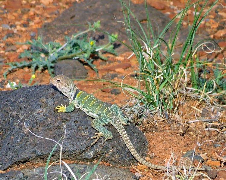
 We relaxed
on Saturday. I did more visiting. Then returned the car and caught our night flight
back to Boston.
We relaxed
on Saturday. I did more visiting. Then returned the car and caught our night flight
back to Boston.I had a great time connecting with some old friends and relatives. My Aunt Shirley, Shawn and Teri S, my Aunt Ellyn, Star and Ken C, Brian C, Keven and Linda H, Tim O, Ken S, and Mary & Cindy P. It was fun talking about the old times and getting caught up.
Arizona is a big state with a variety terrain, climate, etc. The Camaro had 6300 miles on it when we started. We added 1205 miles over the week. I told Kevin we didn’t go south or east from Phoenix so we have more to explore next time.
Go to: "Search This Blog" at the top of my page and type in "Vacation" to see past posts.


a.jpg)

No comments:
Post a Comment